The lakes of the Emparis plateau - Hiking from Besse-en-Oisans

Description
TECHNICAL INFORMATION
Start: Parking Beyet (at the end of the village of Besse).
Ascent: 1,060 m
Duration round trip: 5 h outward journey and 4 h return journey
Return distance: 18.5 km
Level: Difficult
MAP AND TOPO
IGN TOP 25 map 3335 ET (Le Bourg-d'Oisans - L'Alpe d'Huez)
Topo map OBP n°3 (Oisans au Bout des Pieds)
ITINERARY
Start at the Beyet parking lot on the outskirts of the village of Besse.
Walk straight on for about 2km to the municipal bivouac area at Le Gay. Walk past the bivouac area, take the track, then take the path that climbs to your left. The GR54 signs indicate that you're on the right track. The climb to the Col Saint George (700 m ascent) takes around 2h30.
Once at Col Saint George, the climb gives way to a gradual descent to the center of the Plateau ("Plateau d'Emparis" on the yellow signs) over about 2 km. Here, you'll pass close to the Rif Tort marsh and move through endless meadows that resemble Mongolian steppes.
Once you've reached the center of the Emparis plateau, head up towards the Col du Souchet.
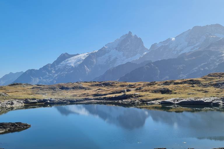
Once at Col du Souchet, leave the GR and head for the lakes: first follow Lac Lérié. If you're lucky, you'll be able to admire the reflection of the Meije glacier in the lakes.
After Lac Noir, head for the center of the Plateau d'Emparis, then return to Besse on the GR.
THINGS TO SEE
- Plateau d'Emparis
- Marais du Rif tort
- Lac Noir
- Lac Lérié
NEARBY ATTRACTIONS
- Besse village
- Maison des Alpages